")
")


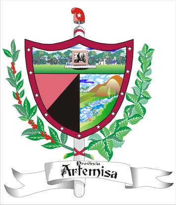
The shield.
The shield of Artemisa province assumes the configuration of an ogivaladarga, similar to that of the National Shield.
The decorations the shield assumes are partly the same as that of the National Shield, the lictor sheaf and the frigio cap. There is a branch of tobacco leaves on the right side of the shield which represents the eastern territory where tobacco is grown. The best tobacco leaves used to cover the cigars are produced in the Ariguanabo region. There is a branch of a coffee plant on the left side of the shield which represents the western territory where coffee is grownjust in the mountainous region of Rosario’s Range.
The bordure of the shield is in fact an honorary piece and is represented by a reddish heraldry which symbolizes the high agrological capacity of the prevailing soil in the south part of the territory.Eleven stars are distributed to represent the number of municipalities in which the province is divided.
The body of the shield is divided into three parts to show the three areas which make up the relief of the province: the plain, the pre-mountain and the mountain. The image of the Mausoleum, National Monument, appears in the upper part of the shield, erected in honor to the Martyrs of Artemisa. This site has become a provincial symbol and is identified by the artemiseños as a fundamental element which constitutes the image of the city. Two stripes appear on the inferior part of the shield, one of them is red and the other is black and represent the Movement July 26th and the outstanding role played by the sons of this province in the Moncada’s revolutionary actions, the secrecy, the assault to the Presidential Palace, the landing of the Granma and the strives in the Sierra Maestra mountain range.
Three elements are noticeable in the inferior part on the right. The first is a river, which represents the numerous hydrographic net this province counts with. San Cristobal, Ariguanabo, Rio Hondo, San Juan, Bongo, and Santa Anaare the most outstanding among others. The second element is the cultivated soil, which represents agriculture as the fundamental economic base of the province. The third element includes the mountains and their forests. The presence of a mountainous area in the province is representedwith its highest elevation, Pan de Guajaibon.There are also several protected areas and ecological reservations. Sierra del Rosario stands out among those.
Read more...